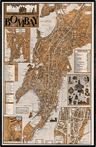
1967 City Map of Bombay
Regular price
$24.50
This is a 1967 city map of Bombay (now Mumbai). The map depicts Bombay from the Mithi River (Mahim Creek) to Colaba (Colaba Point) and from Malabar Point to Wadala, Sion, and Kurla. Created for the International Tourist Fair held in Bombay that year, several points of interest are depicted, including the Mahalaxmi Temple and the Gamudra Mahal. An inset along the right margin, titled 'Beautiful Bombay' includes other 'popular land marks' including the Aarey Dairy, the Rajabal Tower, and the Gateway of India. Roads, railways, and sea routes are labeled. Several other inset maps are included around the border, including a detailed map of Fort Bombay, a map of the Bombay city and suburban railway system, and a map of 'drives to scenic and interesting places in and around Bombay.' To aid foreign tourists, there are also lists of places of interest, important hotels, and cinemas along the left border. Distances to other cities in India, including Delhi, are given along the top and right side border, and distances by sea to international cities are listed along the bottom border. An incredible depiction of the Gateway of India sits atop the title, offering a striking impression.
-
11" x 17" matte paper
-
Reprint of the original map. The map has not been retouched and sold as is.
-
Frame not included
-
Frame used in photo: https://amzn.to/3O81zfa


